A Pattern of Repair: The Traffic Bean
Article Table of Contents
- Introduction
- 17th & Monaco Traffic Bean
- On MUTCD Compliance
Junction Efficiencymodeling: Vehicles Per Square Meter Per Minute- animation of what 3x efficiency could look
- Some Mockups to convey the vibe
- How to deal with “incorrect speeds”?
- What if even those curves don’t work?
- Calculating
vehicles per square meter per minuteof Poynton, UK shared space ‘traffic bean’ - Frequently Asked Questions
- Additional Reading
- Footnotes
Introduction #
note: the above reading time is counting towards the word count all the javascript animating this animation, the actual reading time at 250wpm is 25 minutes
This whole resource is a collection of threads about this thing called ‘the traffic bean’ and a particularly gnarly junction near me. I live in 16th, this junction is one block north of me and a few miles east of me, 17th & Monaco.
The ‘traffic bean’ is what I’m calling this ‘shared space roundabout’ installed in Poynton, UK. Here’s an explanation of it:
It’s important to know how a junction might look in normal conditions, so here’s a few minutes of continuous timelapse I sourced from a kind person on Reddit, July, 2025:
I first articulated the idea of a ‘traffic bean’ here on my substack, applying it to Colfax & Franklin & Park, mostly.
The ‘traffic bean’ concept is based off of Poynton, UK’s rebuild of a shared-space traffic bean concept
Here’s two still images that convey the vibe.
First, notice the shape I’ve drawn over the junction mockup. This mockup is for work that was planned (and has now been finished, as of 2013) in Poynton, UK:
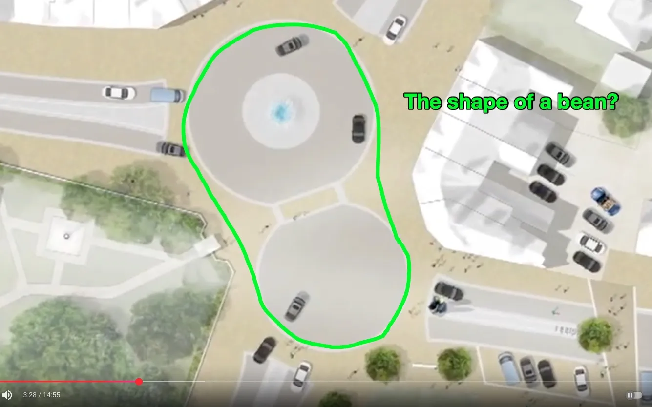
As a reminder, here’s what beans may be shaped like:
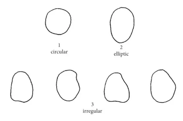
So, an ‘irregular circle’ could be considered a bean. Thus, a ‘traffic bean’ shares some conceptual overlap with a traffic circle.
I’m also suggesting a deviation from what Poynton, UK does - in Poynton, the entire center area of the junction is allocated to cars, so they can drive straight through if they want - I’m suggesting that the ‘circle’ shape be maintained, with the center of the circle kept open for people, not cars.
here’s one of my own recent videos about junction efficiency:
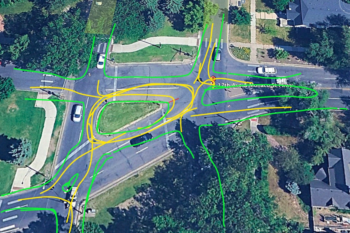
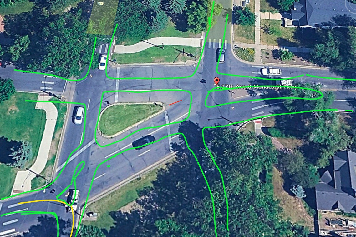
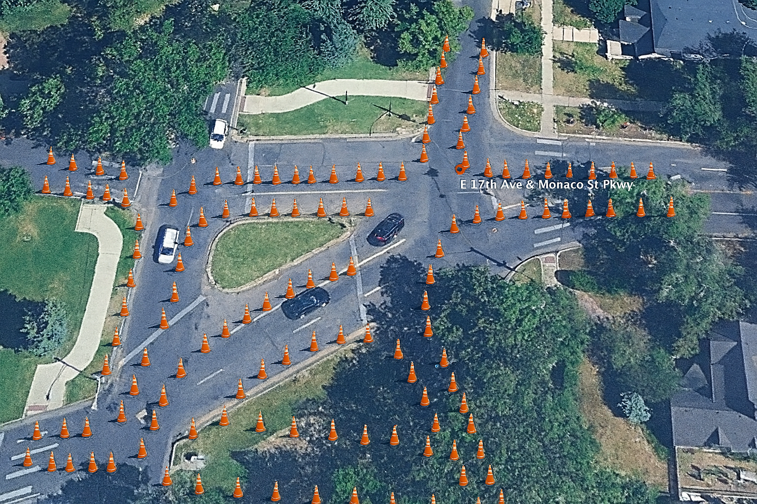
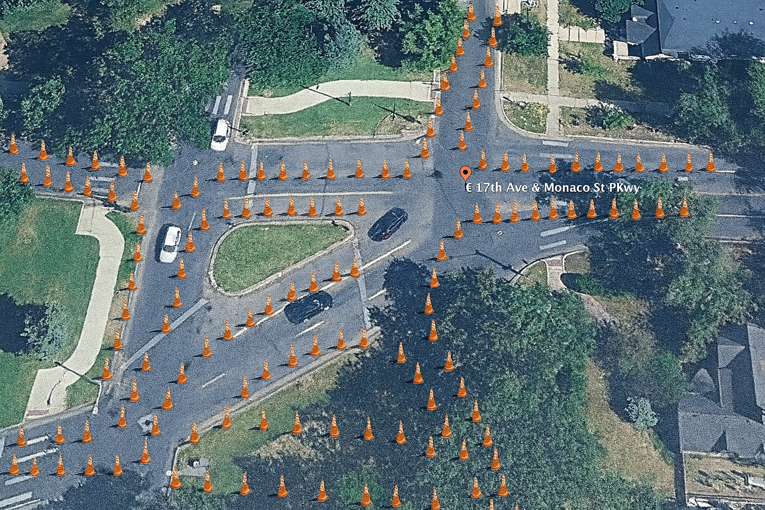
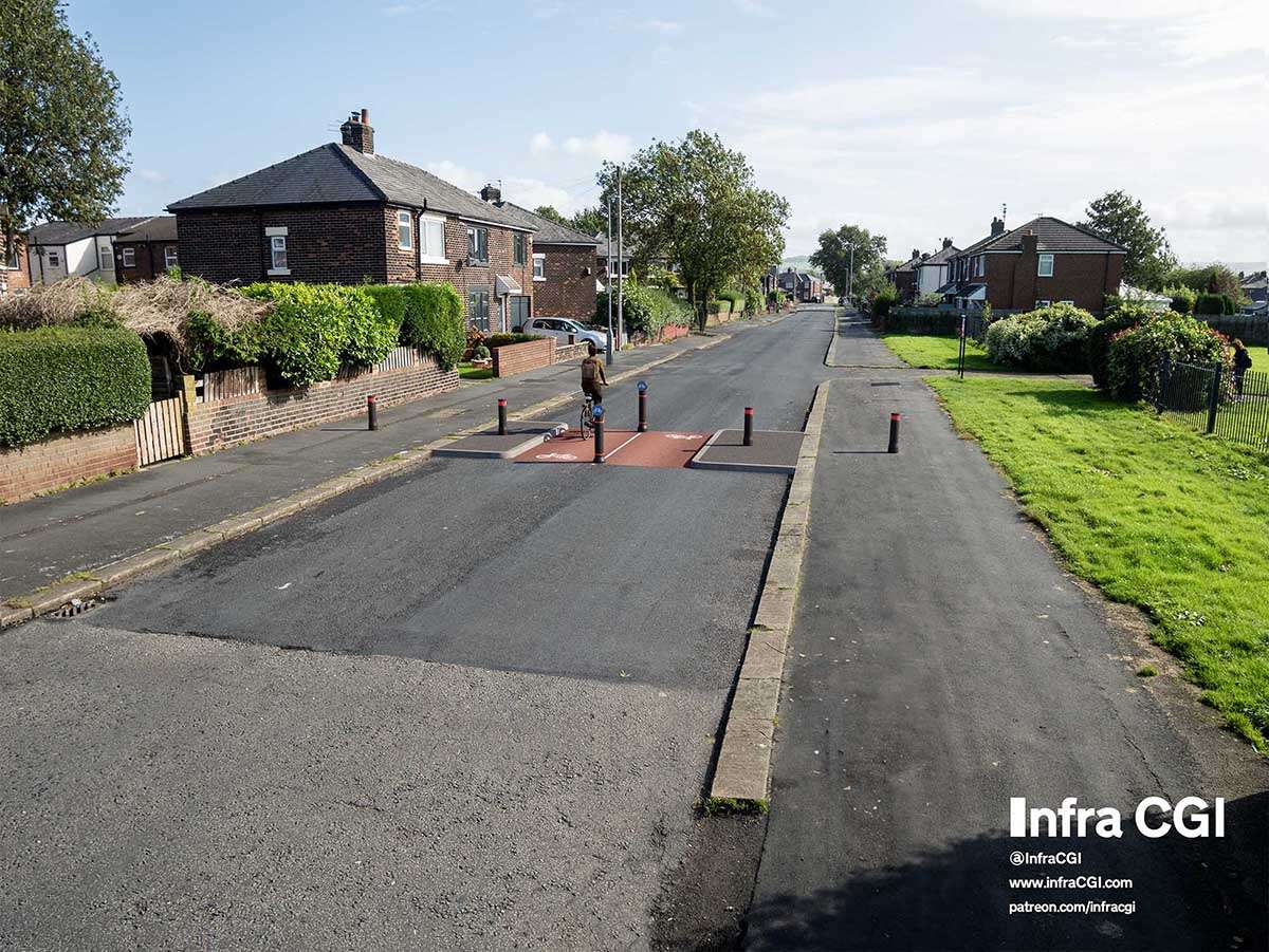
17th & Monaco Traffic Bean #
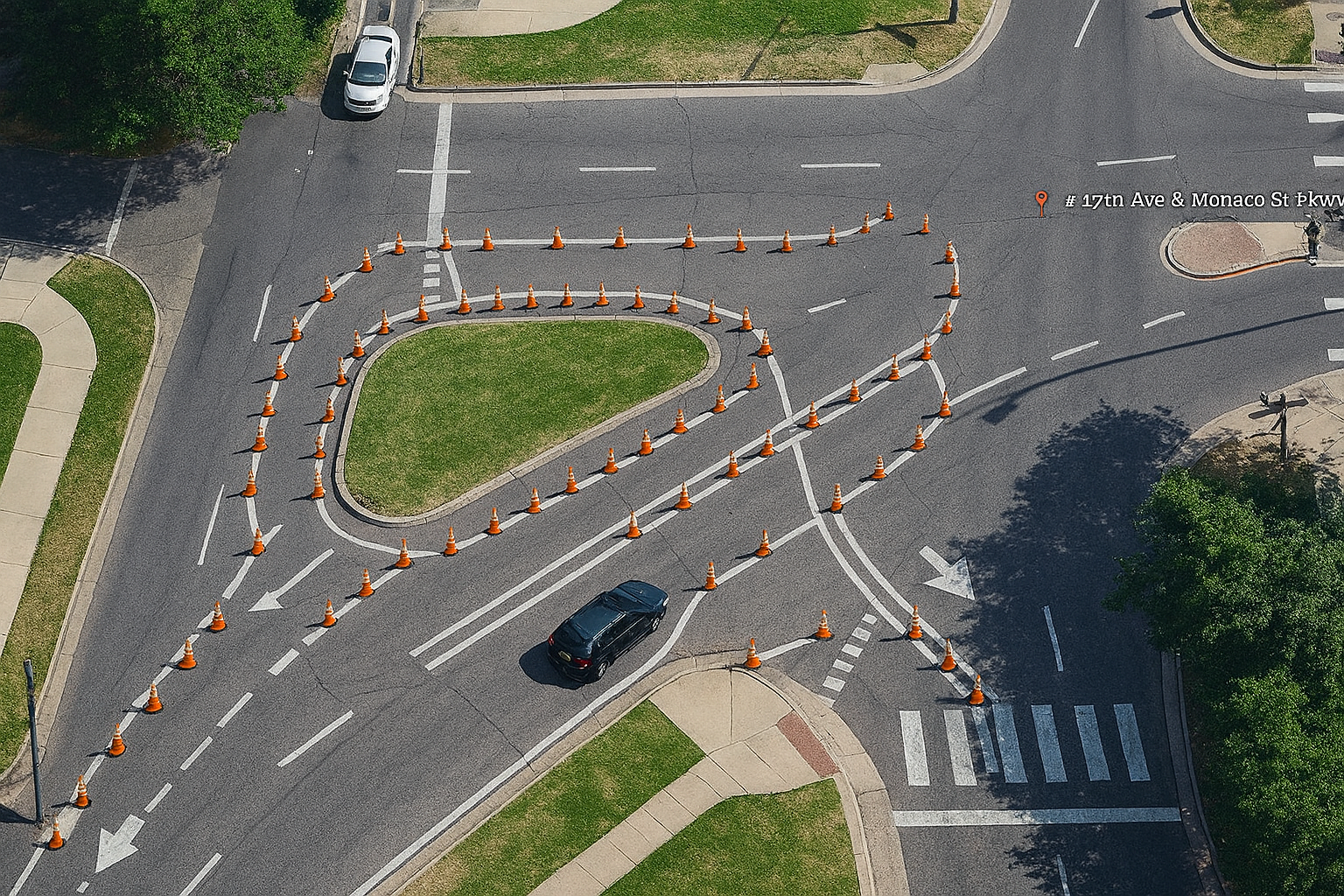
Here’s sorta what I’m thinking. The shape would be initially provided by orange traffic cones, until the right shape and curves are found. Cones allow permeability by people walking and biking, so lots of the space would be ‘reclaimed’ for non-car uses
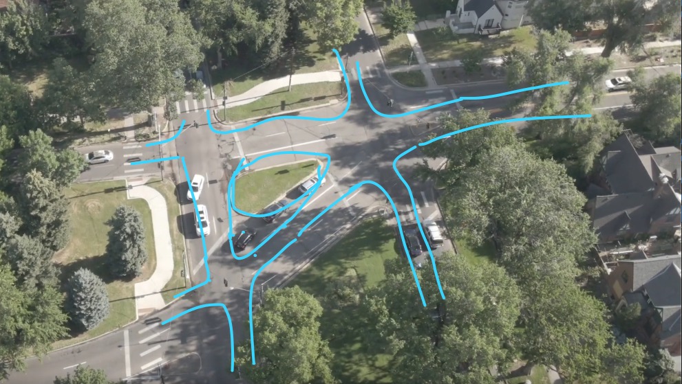
Here’s some footage of the intersection - I’d not even really thought of the application of the traffic bean concept to this junction until long after seeing it the first time. I originally went out there after reading this article, found it in a very relatable subreddit, r/fuckcars
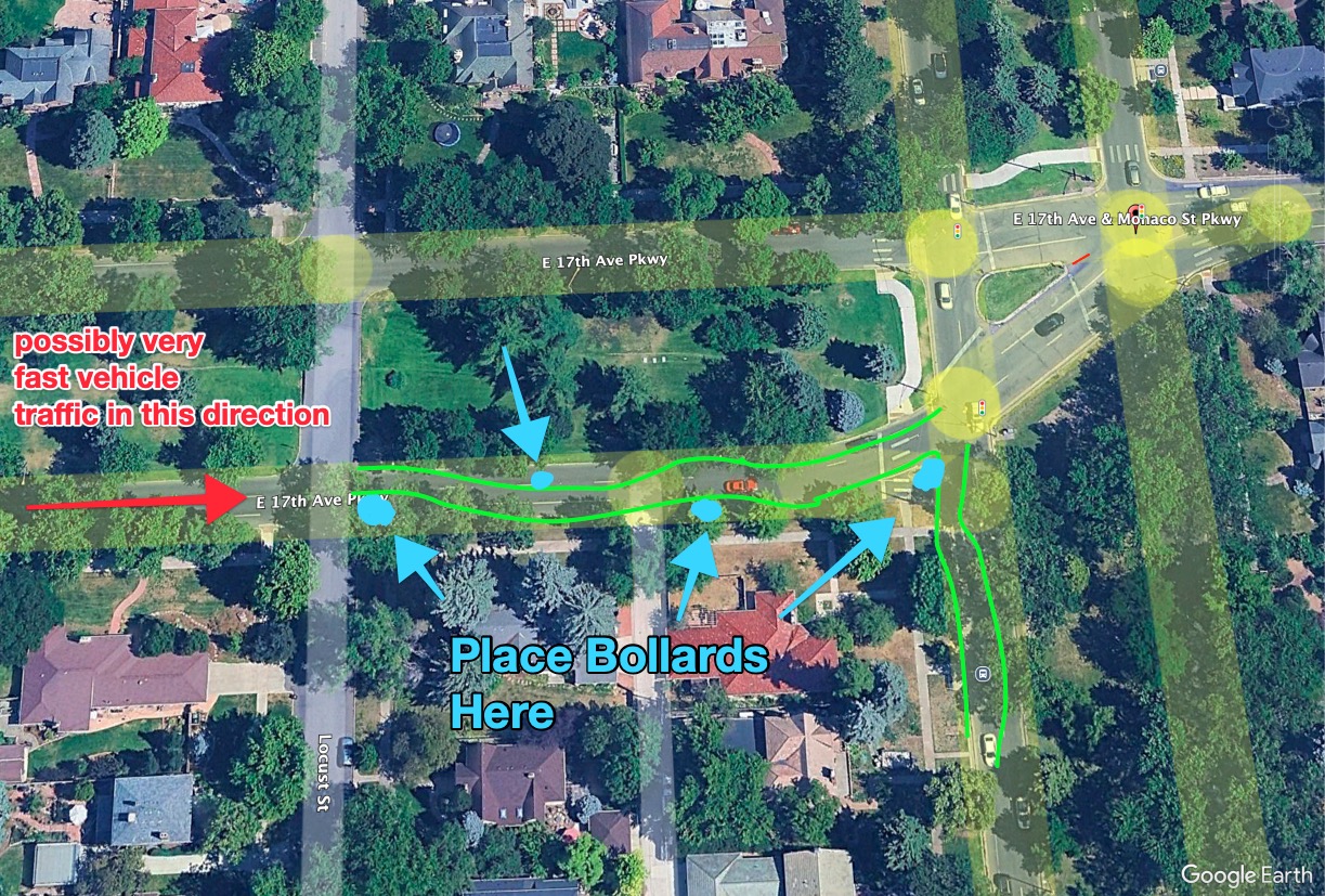
Popped down to see how the owner of the house would feel about adding some bollards. My initial thought was to get some heavy boulders/bollards1 placed in the obvious spots. Might still do that! But beyond the boulders, the entire junction really could be, should be, rendered safe. If there was a car in the way or a person, the next vehicle might still crash into the house, but it would also hurt the other people who had nothing to do with the overly fast vehicle.
So, a traffic bean, especially mixed with some bollard-type rocks in the median between Monaco northbound/southbound, and a few more in the front yard of the property in question.
Here’s some from tiktok, me showing how the traffic bean could/would function, using the convenience of my scooter.
This would be the same experience a larger vehicle would have, too, except likely even less stopping and waiting for passing traffic.
insta360 footage, on my scooter, treating the center island as a traffic bean (tiktok) (a direct link)
below is an embed from tiktok, that depending on your device’s browser’s settings, may or may not render:
@boardsfast
On MUTCD Compliance #
The Manual of Uniform Traffic Control Devices (pdf from dot.gov) is a chunky 900+ pages. I don’t have a paper version. Do you?
This traffic bean project is designed as a low-cost, reversible pilot demonstration, informed by MUTCD guidance and implemented under engineering judgment, to test improved traffic flow and pedestrian and vehicular operator/passenger safety. This pilot aligns with the MUTCD’s stated goals of improving the safe and efficient movement of people and goods — particularly vulnerable road users — through clearly communicated, low-speed, high-attention intersections. (see section below on relative values of vehicles per square meter per minute throughput)
There’s two key provisions we’re going to implement, from this document, to be in accordance with the guidelines of this document:
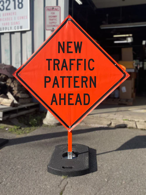
‘New Traffic Pattern Ahead’ sign #
The first piece of signage is, of course, an indication to drivers that things are about to be different. There will be ways of helping them pay attention beyond just this sign, but we’ll use a NEW TRAFFIC PATTERN AHEAD MUTCD W23-2: for each vehicular point of access. It’ll look something like:
Exercising judgement, engineering study #
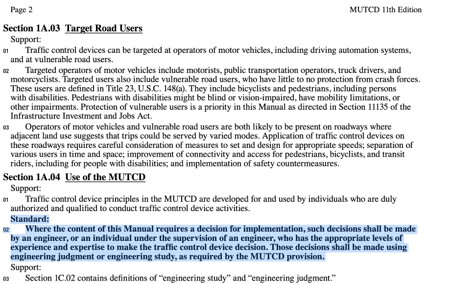
After 36 pages of Table Of Contents, on page 3 of the MUTCD 11th ed, there’s a line:
Section 1A.04 Use of the MUTCD, paragraph 2:
Standard: 02 Where the content of this Manual requires a decision for implementation, such decisions shall be made by an engineer, or an individual under the supervision of an engineer, who has the appropriate levels of experience and expertise to make the traffic control device decision. Those decisions shall be made using engineering judgment or engineering study, as required by the MUTCD provision.
in the original:
poynton, UK’s answer to the same question. #
In the video about Poynton, there’s a few sentances given to compliance with the UK equivalent of AASHTO or MUTCD, I believe the principal holds, discussed at the 9 minute 35 second mark of the video, which should be queued up in the below clip:
17th & Monaco: Updates after the meeting with various city offices Tuesday, early July (the 8th) #
The junction needs to be fixed, obviously, but not with punishment or enforcement energy. The Denver Police Department’s staffing levels for speeding/speed monitoring is down quite a bit, according to my conversation with the police officer at the meeting, and even if it wasn’t, relying on police and the implicit threat within them to change driver behavior is not interesting. He reported being pleased at the idea of no longer having to respond to accidents, fatal or otherwise, at 17th and Monaco.
People move around based on the environment. When is the last time you walked or drove directly into a tree? That you didn’t walk into a tree isn’t because of enforcement, but because something about the treeishness of the tree caused every part of your brain to consider that space unavailable and uninteresting to you.
The same principal can be brought into ‘traffic engineering’ or ‘mobility network design’.
I don’t presume that every square meter of asphalt is 1) the same as every other square meter of asphalt, or 2) belongs to cars.
Roads are a key part of a mobility network. Mobility networks exist to move people/vehicles around.
Here’s how I evaluate mobility networks:
Junction Efficiency modeling: Vehicles Per Square Meter Per Minute #
One could imagine a metric for evaluating junction efficiency, for comparing different junctions, or junction designs against each other and themselves.
I ended up moving most of this conversation to a dedicated post:
👉 A Junction Efficiency Metric: Vehicles Per Square Meter Per Minute
The video is running at a 3x timelapse, in a continuous fashion, so every vehicle can be counted. It was taken at the peak of a morning rush hour. On my scooter I’m unimpeded by traffic, so it’s effortless for me to pop out to somewhere, even when traffic is maxed out.
five minutes is 300 seconds, and since the video is a 3x time lapse, that means I’m going to count the total number of vehicles that pass through the marked polygon in 100 ‘video seconds’:
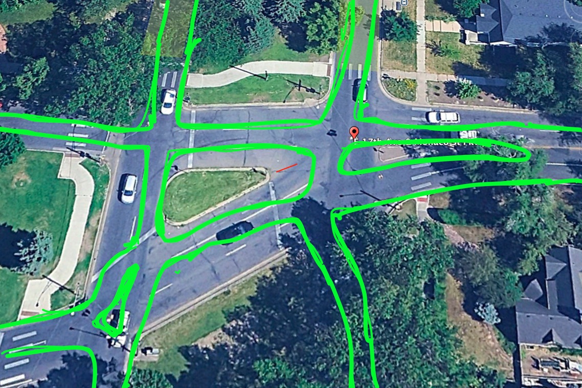
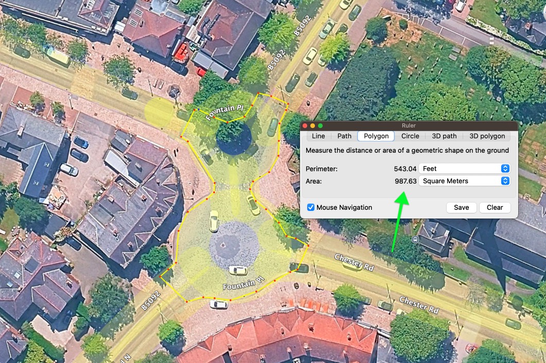
Before we start counting, lets determine exactly how large the junction is:
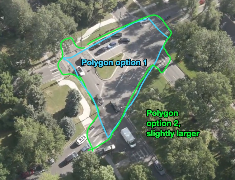
Lets see the square foot value for both of those polygons. We’ll do the math all the way through for both, of course.
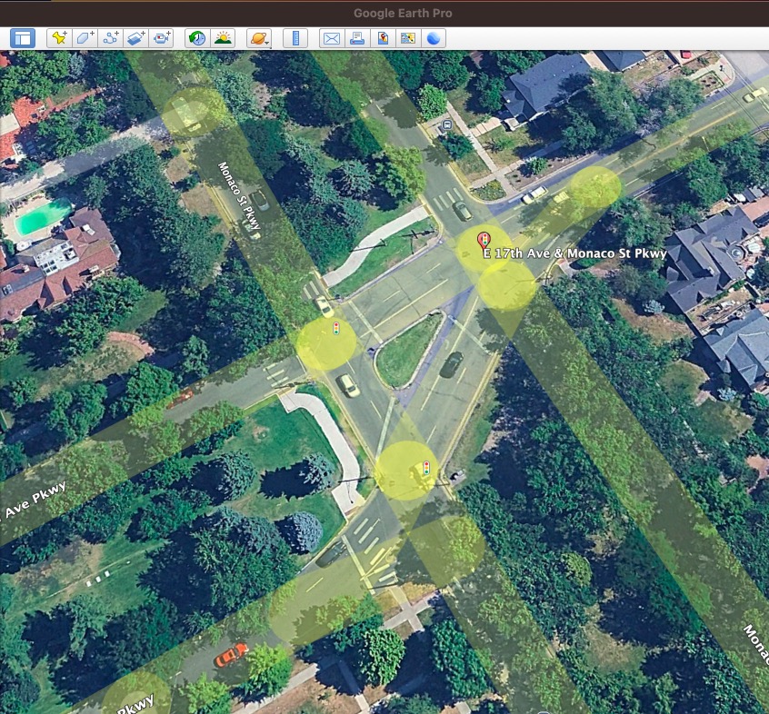
Above is the view of this junction in google earth. Next I’ll use the measuring tool to open a polygon drawing menu. The image below is what this looks like:
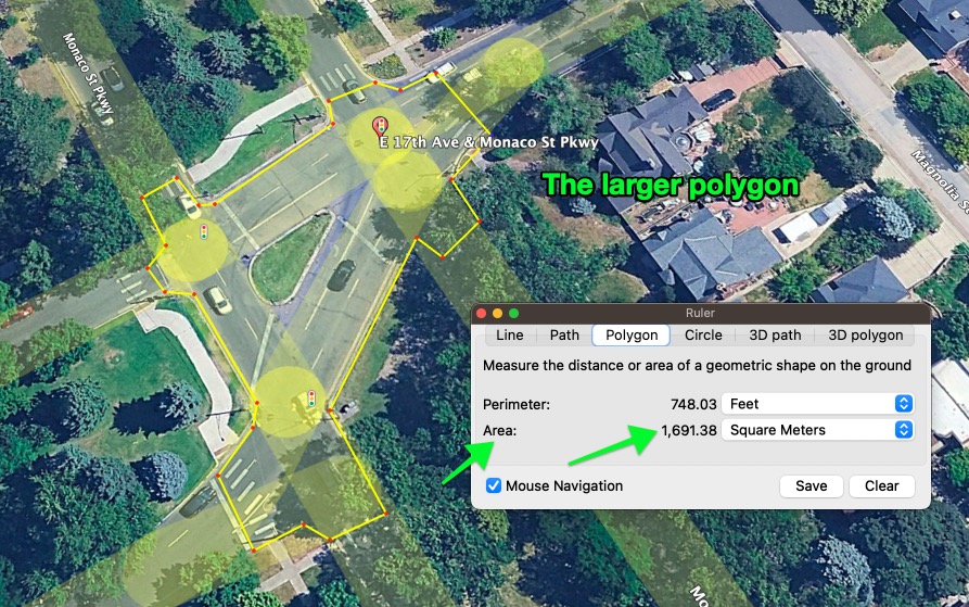
So the ‘larger’ polygon is 1691 square meters.
Lets look at the smaller option:
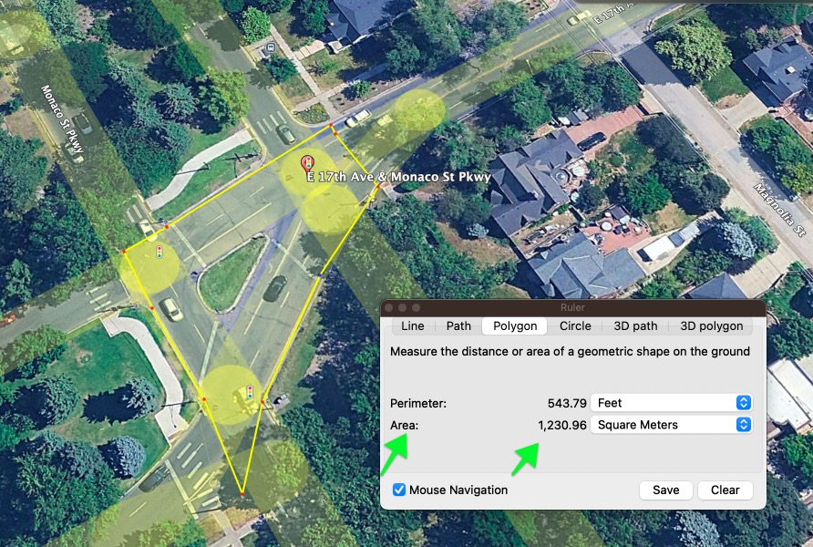
Simple enough, the smaller polygon is 1230 square meters.
I’ll pause here for now, but the next step will be to measure the vehicles entering that shape.
I’ll use the video I mentioned before, starting from when the intersection comes into view at the 15 second mark and continuing to the 115 second/1:55 mark, which is an equivalent of 5 minutes of real-time car counting.
How I do the counts #
Feel free to check my math or methodology.
[I moved a bunch of text from here to the dedicated vehicles per square meter per minute post]
So, like we’re discussing, how many vehicles in 5 minutes? 203 vehicles in five minutes
Let’s plug these values into the formula:
203 vehicles | 5 minutes | 1690 square meters
0.0240 vehicles per square meter per minute
Or flipped:
1 vehicle per 41 m² per minute
41 square meters is about the size of:
- A small studio apartment (6.4 m x 6.4 m)
- Half of a tennis court
- A single parking space (with buffer) plus some sidewalk
Half of a tennis court to move a single vehicle in a minute? Seems ‘obviously inefficient’ to me.
how to make it better #
The way to make it more efficient, at first pass, would be to simply find a smaller area for the junction.
For instance, compare the following:
203 vehicles | 5 minutes | 1690 square meters
203 vehicles | 5 minutes | 550 square meters
the second junction, at 1/3rd the size, could be construed to have a 3x efficiency. (7% of a vehicle per square meter per minute instead of 2%).
animation of what 3x efficiency could look #
3x the efficiency could be achieved purely by making the junction much smaller - 500 square meters vs 1600 square meters.
Here’s a way this could be visualized. Do you see a the way that this exhibits better efficiency? This is only one possible way the difference can be viewed, obviously. This isn’t how junctions work exactly, but it perfectly shows one of the dimensions of efficiency improvements.
Intersection Efficiency Comparison #
If you had limited space and needed junctions in three different places, and nothing else about the space could be used for anything BUT moving these vehicles, which would you want more of?
Both intersections process 203 vehicles in 5 minutes
My desire with the traffic bean isn’t even necessarily to move more cars through - it’s to reduce certain forms of pollution, difficulty, distress, waste, excesses. One of the ways it does this is by reducing the physical space allocated to the junction.
[lots more of this conversation got moved to the vehicles per square meter per minute piece]
Achieving a 400 square meter junction #
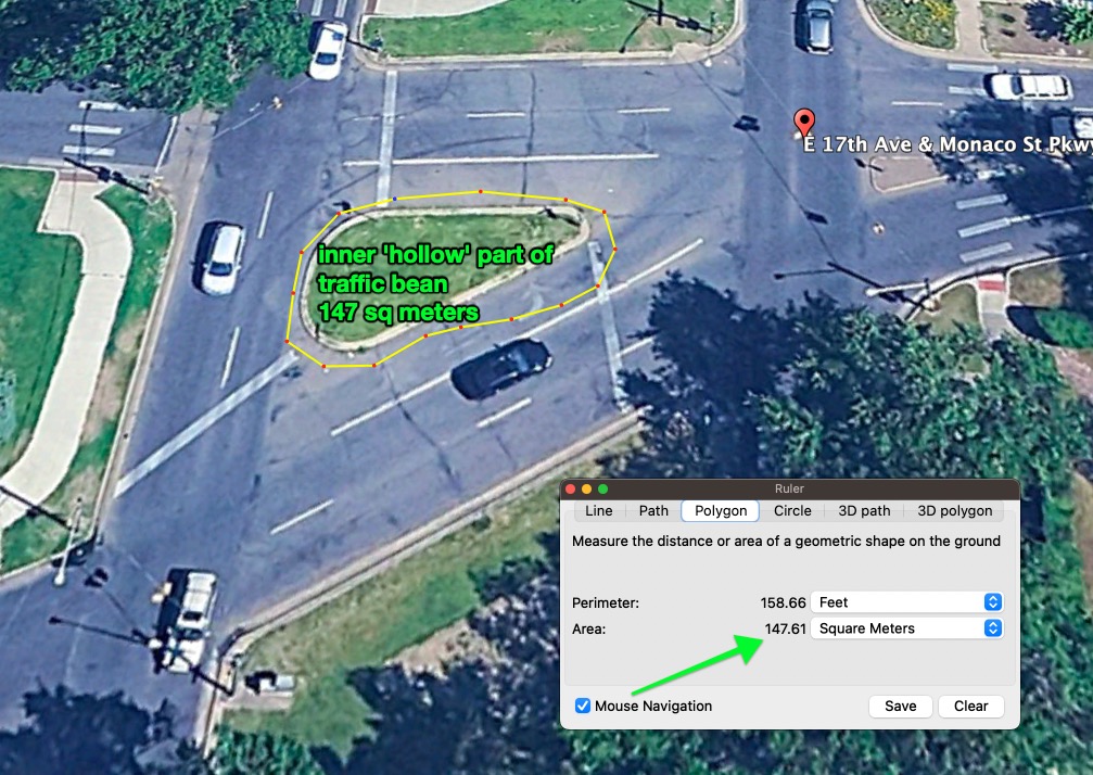
to get this junction, we’d want something bean shaped, with the inner shape hollowed out, like a doughnut. This frees up lots of square meters.
A bunch of space saving comes from the ‘hollow’ inner space of the traffic bean. We’ll determine an inner shape that will get subtracted from the outer shape.
The following shape is 147 sq meters:
So, this inside space can be subtracted from the outer space. Lets jot down a shape that could work for the outside.
It needs to be only a single lane wide, with entry/exit points wherever needed.
How would you feel about this shape? its 360 sq meters, which of course includes the 147 sq meters we’re gonna count as ‘for the people’ and not as space for cars:
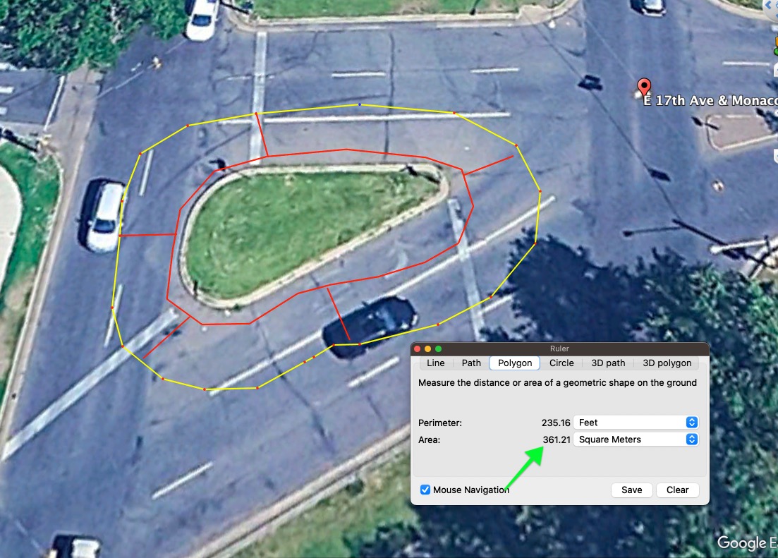
its 360 sq meters.
so, less the inner area that doesn’t need to be counted,
360 sq meters (outside shape) - 147 square meters (inside shape) = 213 square meters
I had proposed that this junction could be 400 square meters, and we’ve used only a little more than half. I don’t think it will take 200 square meters to provide the access points for vehicles. the main shape could be clear now, I think, thus ‘the vibe of what I speak’.
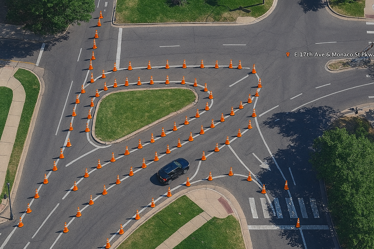
Lots of the remaining space would need to be ‘shaped down’ with traffic cones, until the right shape was found. Here’s a very crude example:
The red inner lines are 11 feet long, which is certainly not a wide lane, but isn’t super narrow, either. The dimensions here are pretty comfortable, even for commercial vehicles, I think. A normal sedan is almost 6 feet wide (and 14 feet long) A cement truck is 9.5 feet wide, including the mirrors, or 8.5 feet not including mirrors.
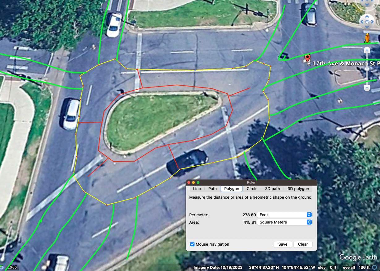
The above was my super wonky first mockup. Can you see what I’m aiming for, even as it’s obviously not the exact right shape?
The junction has sorta widely-separated inputs and outputs, so this is a sorta extreme example of the paths that would be ‘carved out’ of the existing junction space.
A note about the shapes #
What I’d suggest is that these shapes, the shapes of the lines, boundaries for cars, be ‘drawn’ or profiled, initially with the humble orange traffic cone.
Traffic cones are no barrier to anyone but cars, so ias people are walking or biking through the area, they could easily cross perpendicular to the vehicle traffic, barrier free.
The cars would stick to the paths, everyone else would move however they wanted.
As is visible in this timelapse video from Poynton, pedestrians easily, safely cross the paths of cars. This is the exact same vibe I’d be aiming to replicate, and it would be easily ensured by putting ‘gate-like’ patterns of cones down, for the cars and pedestrians each, wherever there’s anticipated points of crossings.
check out my series on coning to see videos, footage of other places I’ve placed traffic cones. It’s very easy to get the kinds of behavior one wants from drivers with traffic cones.
Some signage on the inbound lanes would say ‘shared space’ or something, and there would begin to be affordances to the space of the junction being a ‘shared space’.
Same as Poynton, there would be signage that says ‘shared space’ and curves such that vehicles move slowly enough. there could be an arbitrary design speed (13 mph?) that is achieved by people at the fastest part of the junction, and one would simply shape the curve to achieve that speed. 2
I have a video elsewhere on this page of me driving around and around and around the traffic circle, sorta profiling the shape of this bean. I was moving slowly, a car could have moved as fast as me. That shows how quickly a junction like this could ‘clear’ a vehicle, no stopping required. Much closer to 1 vehicle per meter per minute.
Here’s the video:
@boardsfast
Some Mockups to convey the vibe #
Here’s an image with some modifications provided by chatgpt. It’s not perfect, but I think it’s interesting. Here’s the crude images I gave the model, I provided the following annotated screenshots:
And it delivered pretty neat images! Not necessarily ‘syntactically correct’ from a vehicular flow perspective, but I believe some of the vibe is being conveyed.
I note the first image I fed it of mine also isn’t quite syntactically correct.
Like I said, these are not ‘syntactically correct’, but I notice on the source images, I didn’t bother to provide possibly relevant detail for some of it. Let’s create an accurate sketchup, and see if ChatGPT can generate a correct result. I’ve never tried this exact thing with chatgpt before. Only recently did I do my first image modification with it!
Here’s the next source image. I’m calling it “syntactically correct” in that this particular shape would solve the problem of the intersection:
The prompt I’m giving chatgpt:
This image I’m giving you now I’m calling ‘syntactically correct’, in that it actually works to solve the intersection, based on the current configuration. Could you draw the shapes of the green lines in traffic cones?
I note that there would be, then, two ‘islands’ of cones, to keep up with what I’ve drawn out. A long narrow one on the top right, and a sorta triangular one on the bottom left.
The width of the travel lanes could be about 11 feet.
Here’s the result. Again, pretty good!
Anyway, with the above image(s), and some cones, I think nearly anyone could now correct this junction.
A correct-enough mockup #
Here’s the last mockup I gave - it’s ‘even more correct’ than before. I actually sorta like this design:
and chat gpt gives me a pretty correct image. Based off these last two, I think it’s clear what I’m suggesting:
How to deal with “incorrect speeds”? #
Some people will not have a correct entry speed, given the POV of these screenshots. If everyone was entering the frame at 10 mph, maybe it would be perfect, but the whole thing that kicked off a conversation about this junction was that at least a few times a day, someone is going 90 mph + (and all other forms of excessive speeds) on the road entering the bottom left on the images. It’s vehicles entering from the left, a long straight road that sorta begs people to go fast, if they’re at all inclined. 3
The way to bring speeds down is to gently begin to ‘shape’ the flow, with traffic cones. Starting by cones on the outsides of the lanes, then whenever it’s decided to make it a single lane, do so. (At least a block away). One’s it’s a single lane, add some curves or ‘horizontal deflection’ until satisfied.
Watch the way people drive through the space, and iterate until it’s nice.
I refer you to my piece on coning. Lots of examples of people’s speeds becoming very reasonable JUST by making something like a ‘gate’ out of a few cones bunched up across a relatively modest distance. Maybe do a gate, then another gate, then a little bend, so from the POV of the beginning, the sight line doesn’t go all the way through.
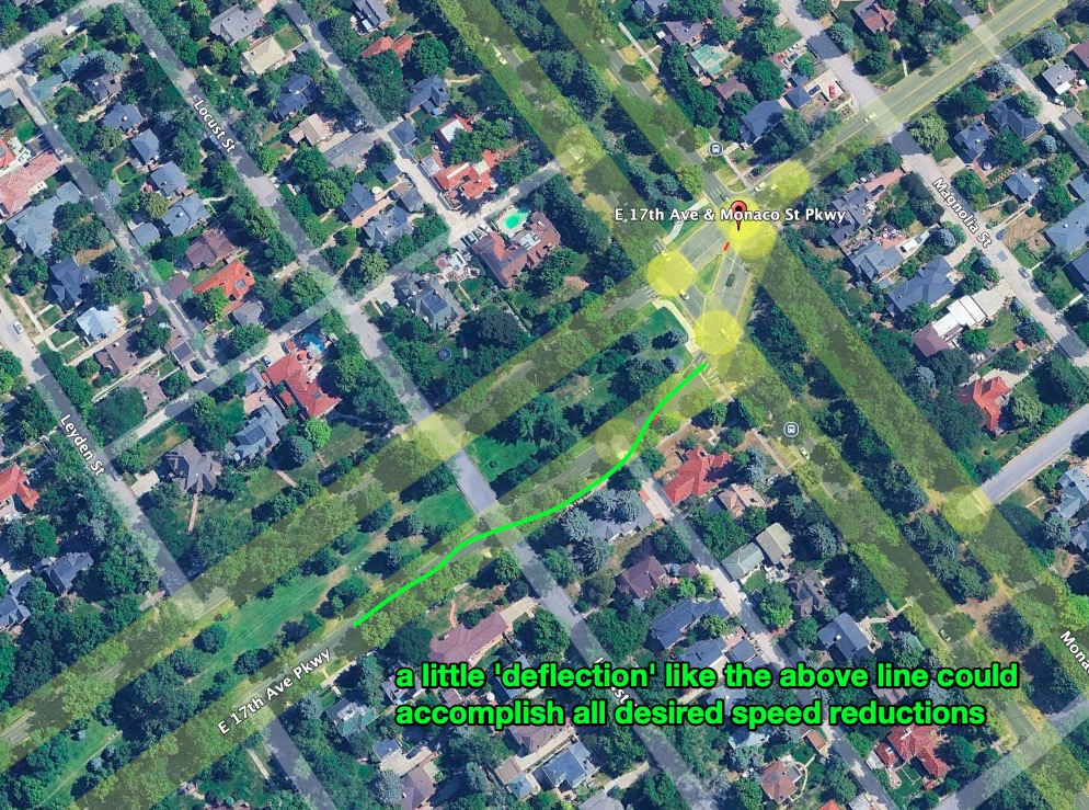
And there we go! Wherever there’s potential of excessive inbound speeds (which would probably be all inbound streets) make sure they’re shaped to a single lane and about 18 mph with some curves. 4
What if even those curves don’t work? #
Great question! Sometimes just because a vehicle has to go below a certain speed to navigate a certain curve doesn’t mean any particular vehicle will go the correct speed. What’s stopping a car from crashing through all the cones, and making a mess of everything, even at like 80 mph?
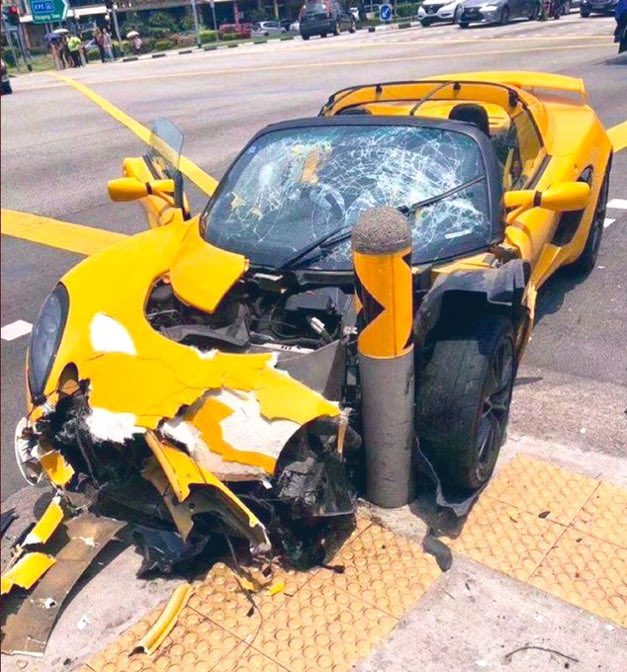
Again, in this article about the specific house that’s gotten crashed into 5 times in 16 months, sustaining hundreds of thousands of dollars of damage and near deaths of the family more than once. 5
TODO: add link to video of car driving down long rows of flex posts
We all know that nothing about the best laid out plans, or cones, “guarantees compliance”. You know what does help with compliance? Not cops, not speed radars.
Bollards. And curves.
Bollards “help” so much with “compliance”. here’s my original love letter to bollards
For now, I’ll re-use an image that shows what we love about bollards:
So, this is how one achieve’s speed management. It’s a familiar strategy, once you know to look for it. Let’s say we have cones laid out along the green lines. We’d put bollards behind them in certain spots on the curve:
And just like this, the inbound traffic from 17th would be rendered safe!
This could be repeated for Monaco, and the other inbound direction of 17th. I’d suggest it would need to be implemented as the ‘transition zone’ into this ‘shared streets’ paradigm.
There would need to be ‘new traffic pattern ahead’ sign to make everything MUTCD compliant.
Once that sign is placed, everything goes. It’s pretty cheap online, and Trinity Traffic Control probably already has several of the 36” versions floating around. Here’s an online version of what I’m discussing: Dicke® NEW TRAFFIC PATTERN AHEAD Roll Up Traffic Sign, MUTCD W23-2, Orange, 36” Super Bright Reflective Vinyl
The bollards could start as simple as low piles of bricks, or a bucket with gravel or concrete inside and a two-foot post sticking out the top. It can be destructible, and not stop a car, for now. As long as it makes noise and scratches up whatever hits it means it’s good enough for now. Later they could effortlessly be upgraded to something else. I really like bell bollards, because they work in clever ways. They don’t stop a vehicle directly, they just lift up the vehicle so a tire doesn’t touch the ground anymore. Has the same effect. I really don’t want to see anyone hit something at a fatal speed, so there’s lots of ways to signal this sort of treatment, and gently bring someone’s speed to a reasonable level.
For instance, sometimes it’s not excessive speed, it’s inadequate traction - when there’s snow or a particularly slippery storm, all of these interventions still need to work.
I contend that they do. Even in inclement conditions, and especially in inclement conditions.
Calculating vehicles per square meter per minute of Poynton, UK shared space ‘traffic bean’ #
I had the idea of asking in a UK-specific subreddit for someone to graciously help me out by getting a few minutes of continuous video footage of the Poynton, UK traffic bean in operation.
And the internet delivered! A kind reddit user made 2 different videos, 3 minutes each, of the junction.
They also provided a link to resources about the junction, and said:
Basically prior to this traffic was heavy, the village was struggling with shops closing and Poynton wasn’t a destination. Following this deliberate shared space design space is shared between cars, bikes and most importantly pedestrians.
It’s a deliberate removal of all road signs, lanes etc which feels crazy at first but works really well. Drivers are on high alert, safety is improved and it’s allowed Poynton to open up nice cafe bars, restaurants etc with pavement seating etc and the semi pedestrianisation of the area, which is now thriving.
Let’s do some math.
Poynton, UK Junction size in square meters #
This is easy to determine. Open up Poynton, UK in Google Earth:
We’ll call it 990 square meters:
Now, how many vehicles per minute?
I’ll post a time lapse of the two clips I reviewed.
70 vehicles in the first clip, but there wasn’t traffic from all directions with pressure - there was consistent traffic from a single direction, it’s possible more vehicles would fit. Either way, in the video, it’s obviously a generally peaceful flow. not a single vehicle is going fast.
I counted 84 vehicles in the second 3 minute clip. We’ll do some math with these figures:
70 vehicles/990 square meters/3 minutes
and
84 vehicles/990 square meters/3 minutes
Thus, the finished values. The first timelapse:
70 vehicles
990 m²
3 minutes
70 990 × 3 = 702970 ≈ 0.0236
990×370 = 297070 ≈ 0.0236
✅ ≈ 0.0236 vehicles per m² per minute
The second clip:
84 vehicles

990 m²

3 minutes
84990×3=842970≈0.0283 990×384=297084≈0.0283
✅ ≈ 0.0283 vehicles per m² per minute
Compared to 17th & humboldt:
203 vehicles 5 minutes 1690 square meters
0.0240 vehicles per square meter per minute
So, this junction that’s a lot smaller, and has a vastly different design, is at LEAST as efficient as the intersection design we’re replacing.
The Poynton, UK junction itself 3x time lapse #
Here’s the videos I received from the kind person on Reddit, these videos were recorded July 12, 2025:
It’s a 3x time lapse, so has the same time/pacing as the video above of 17th & Humboldt.
Maybe I’ll put them side by side in a future video. Poynton is quiet and safe, while 17th & Monaco is loud, unsafe, inefficient. If we were to calculate some of the harms of 17th & Monaco, we could list many. Beyond the issue of 5 crashes in 16 months, too.
Frequently Asked Questions #
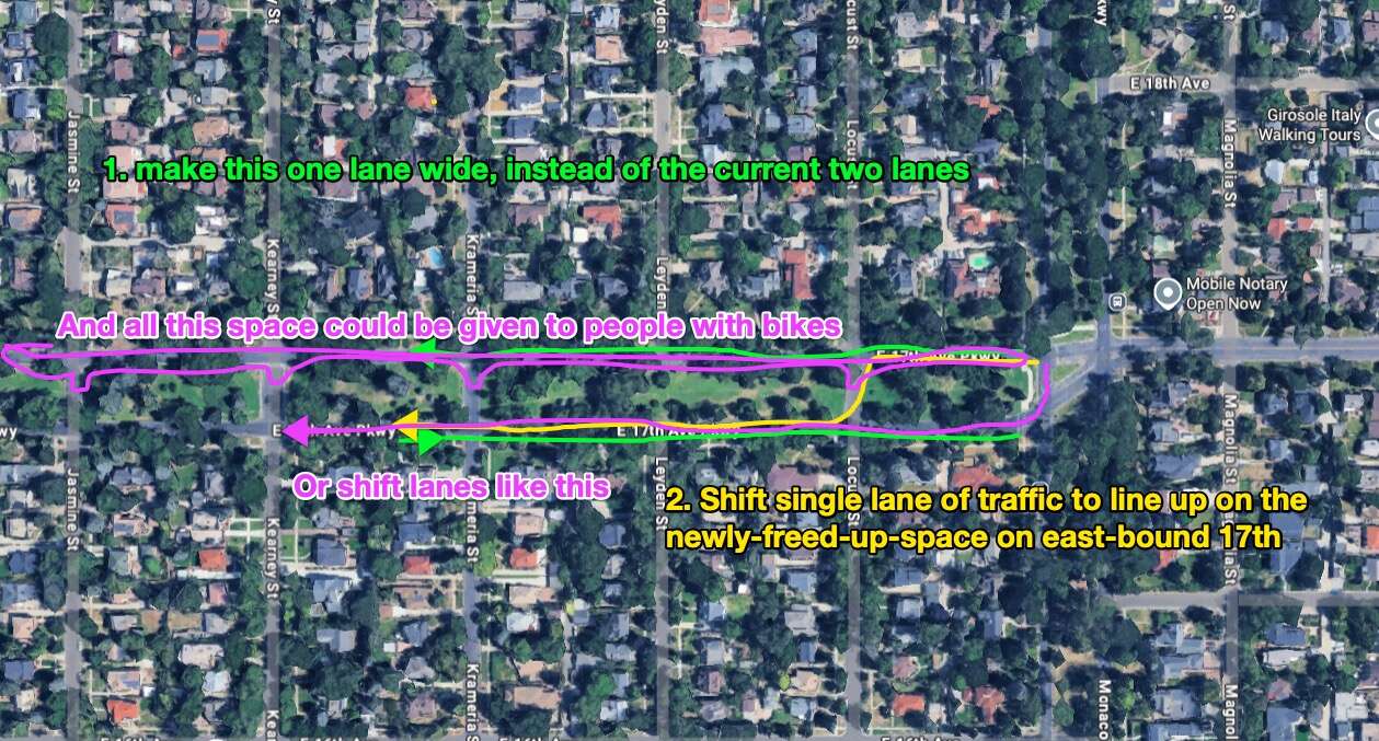
What about the 17th Ave Road Diet? #
I agree, it’s a great idea. There’s at least two ways it could be done. First pass would be to drop eastbound and westbound traffic on 17th to one lane each way (with cones). It could stay one lane each way, exactly as currently configured, OR something else.
Here’s some visuals, pardon me for the ways they’re unclear. I suggest right-clicking/long-pressing on the images and opening them in a new tab - that’ll be the better resolution image
Again, this could all be done iteratively. Also, rather than really ‘closing’ any roads to cars, I would want to add mid-block modal filters occasionally, just to stop cut-through traffic. The result is still similar to ‘giving the space over to non-car traffic’, but still allows vehicles access to the space. Doesn’t make it harder for homeowners to access the space, etc.
Here’s another depiction of this approach. The whole block ‘behind’ a modal filter would be strongly protected by it, it would be quiet and peaceful.
Why not consider dropping modal filters down the whole thing to further pedestrianize it, without closing anything to vehicle access? #
That’s a great idea! I have an eye out on a way to cheaply, iteratively, pedestrianize the whole thing length of the north (or south) side of 17th, while again ensuring lower max speeds of vehicles and improved junction efficiency at every junction. Reducing all of the potential points of conflict between people on foot, people in cars, people on bikes, at night, in the snow, etc, is all top of mind.
If the lowest-effort, quickest path for vehicles is on the south side of 17th, no reason the north could get car-shaped modal filters every block or two:

I’d suggest building modal filters out of traffic cones for starters. I don’t know what pops to mind when I say ‘modal filter’ or ‘car-sized modal filter’ or ‘car-shaped modal filter’.
Here’s a picture I found on the internet of a car-sized modal filter. It’s a filter that ‘filters out’ (same as an air filter ‘filters out’ particulate in the air) a mode of travel.
Here’s an example of what I could mean by ‘car-shaped modal filter’:
This might seem more involved, I’m saying not necessarily that we should start with this, simply that a plan like this shows consideration for pedestrianized spaces and the safety of non-car mobility network users.
Costs to implement? #
I think extremely low cost.
The main thing is dropping off traffic cones and turning off/bagging traffic signals/signs.
I’d do the actual implementation, because the final decision-making needs to be made on the ground, watching vehicles flow towards/around the curves.
It cannot be written up and completely handed off to a contractor, though I’d gladly work with them to get it all placed. Cones are heavy, I, personally, don’t want to place every one of them completely alone. I’ve done it, I’m willing, though.
I think that because the initial implementation is so temporary, so movable, and once installed can be incrementally upgraded to something more permanent, freeing up the temporary parts (cones) to be re-used elsewhere. Clever re-use of materials available on-site could be done.
What about Pedestrian Prioritization #
all the space that is going to be won back from cars with traffic cones will be handed over to pedestrians.
The target vehicle speed when in the junction will be ~10mph, which is slow, and allows drivers to easily stop and allow pedestrians through, whenever a pedestrian shows up ready to cross a junction.
It’ll be much safer and easier than the options for pedestrians in the current junction. In this video from Poynton, UK, one can see how the pedestrians and cars hand off priority. I’d seek to re-create the exact same vibe.
I visualized in this piece that vehicles consume a certain amount of space per second when moving. (and stationary, technically)
This principal is utilized in creating the pedestrian prioritation of the whole thing. jump to the summary of the whole thing here
if it would be helpful, I could do some calculations on something like ‘new square meters of pedestrianized space’. Taking a two lane space to a one-lane-for-cars space (and the other lane for non-car people) is the same as taking a zero-lane-for-non-car-people space and turning it into a ‘one lane for non-car people’ space.
What about Fire Department Access #
I’ve got buy-in 6 from the fire department already, and we’ll of course make sure the fire department vehicles can navigate everything created. In some ways I expect the experience will be easier for the fire department than the current junction configuration.
AND! the current junction generates fire department calls for devastating car accidents, regularly, and just a single accident cost the home owner like $440k in repairs. The current system isn’t awesome, and this thing might work.
Additional Reading #
- I am proposing that the entire first pass of an iterative fix and/should be implemented with traffic cones. Here’s more of my coning projects
- ‘Traffic Congestion’ As Solvable, Part 1: evaluating traffic congestion as simply a result mismanaged street space that could to be handled rightly
- ‘Traffic Congestion’ As Solvable, Part 2: Turning to Junctions, scraping back layers of pseudo-science.
- Traffic Congestion as Solvable, Part 3, Intro to Path Shaping: Cars take space, at rest and when moving, and intersections take space, and can be used by more or less people at once, especially when some thought is given to the paths various can use.
- “But josh {statement in support of the status quo}.” I find the status quo to be less interesting than alternatives. Consider Killed by a Traffic Engineer: Shattering the Delusion that Science Underlies our Transportation System.
- I’ve achieved failures to disagree (a very good thing) with many different people. Thus, I’ve achieved forms of participation and support on this sort of intervention from a few different representative roles: city engineers (golden, loveland, denver?), city council people (golden, denver), a mayor (golden), police (golden, loveland, denver) and lots of residents and mobility network users (everyone, everywhere). People who own and use a car regularly, and people who don’t. Suburb people and city people. I’ve also certainly sometimes annoyed a similarly expansive swath of people.
- Applying the EDG in practice: Active Design Principles (essexdesignguide.co.uk)
- Inspiring Infrastructure: Shared Space at Busy Intersection, Poynton
- details of the ‘traffic bean’, applied to Colfax & Franklin
- Killer Intersections vs. Shared Space: From Intersections that Divide to those that Connect
- shared space (wikipedia)
- what is a shared space?
Footnotes #
-
I’ve written more about bollards. ↩
-
One of the first parts of the substack I stared is about how much speed is used by a vehicle including a two second stopping distance between the next vehicle. ‘Traffic Congestion’ As Solvable, Part 1 Based on such figure (30 feet, for instance) all sorts of useful things can be inferred, like ‘vehicle carrying capacity per lane in a 100 meter block at 20 mph’ ↩
-
I, personally, am a cautious vehicle operator, and even when I’m in a car, I don’t assume anyone sees me. I am quite invisible when I’m on my scooter, obviously. I also don’t believe in the concept of ‘right of way’, so I ride at a speed that allows me to easily verify my safety by checking the sightlines of all cross roads. I never “commit” to a junction crossing until I’ve determined it’s impossible for another vehicle to contest the same space. So I, personally, rarely go above 35 mph on roads like this, maybe 40 max. In plenty of the footage above, my speed begins with a 2. ↩
-
Once the traffic is a single lane of reasonable speed, flowing smoothly through a traffic bean, I’d love to see how it felt giving a similar treatment to the next junction, even though the next closest junction in all directions is an unsignalized junction. The traffic bean pattern solves many/most/all? junction types, regardless of if the current junction is signalized or unsignalized, or has a stop sign, or doesn’t. That’s maybe another blog post. Just know that this pattern theoretically replicates/connects to itself very graciously, leading to great reductions in travel time/time spent waiting around for everyone. ↩
-
It feels like I shouldn’t have to/don’t want to spend many words explaining the impact on ones sense of psychological/emotional safety, after experiencing something like that, knowing at any moment a vehicle could bounce through a wall with barely a warning. The extreme attunement to fast vehicles/racing engines. Here’s the article about the car accidents.
The homeowner now has several thousand pounds of boulders placed on the edge of the property, facing the traffic which is barrelling towards the property like bullets from a gun, deviating at the last second by a well-timed turn of the vehicle’s steering column. So, the property is now structurally protected, and even now, it’s only a partial solution, and this exact solution shouldn’t be doing all the heavy lifting by itself.
Even for the sake of the safety of a driver who, in the eyes of society, might be completely at fault! Even that person deserves a well-enough designed system, and a well-enough designed system might still cause someone to total their car hitting an immovable object at a certain speed, but an environment supporting moving speeds of 25 miles per hour is much gentler than one accommodating 90 mph and then generating perpendicular road crossings and people sleeping in line of those fast vehicles. ↩
-
I wandered into the local fire department one night, basically to ask if their sirens were equipped with a volume control knob. Short answer is ‘no’, long answer is ‘no, with inertia’. I tailed them in on my scooter after following the vehicle around the area for a bit, and being tragically bored by how slow they had to move. I asked if they’d want to move around quicker, less interference from bike lanes and lights, everyone gave an enthusiastic yes.
No one there signed anything saying they thought it was a good idea, but they probably would if I asked them, and confirmed that the vehicles would fit. Everything we discussed and their concerns are coherent with this particular plan. ↩